Compasses: In The Absence Of Technology, A Paddling Nautical Compass Shows The Way Forward

Updated on 7/9/2026
If you are sitting in the cockpit, the nautical compass will tell you which way the kayak is pointing, but it won't necessarily mean where it is going. Your bow may be pointed ENE slightly, even if you're drifting in the northeast. All of these compasses are considered a component of "navigating," but for the time being, let's focus on the compass on your deck.
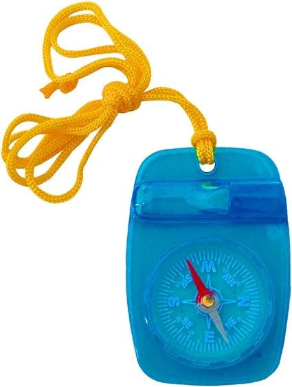
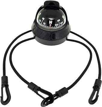
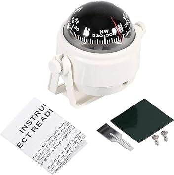
A land compass is often round and flat like a pocket watch and may also be mounted to a flat base. On the other hand, a "marine" compass refers to the dome-shaped bulb compass that many kayakers use and has a dial that revolves on a pivot. Typically, the compass will have an N/S needle that is free to rotate. Most kayakers will either permanently or temporarily fasten these components to the bow deck of their craft by employing a bungee cord, strap, or tie-down system.

In a marine compass, the N-S line should be orientated so that it passes through the pivot point on the compass display and an index mark on the base of the compass. This type of line is known as a "lubber's line." This line should be linked with the kayak's centerline, with the bow pointing north and the stern pointing south. Taking the time to align the N-S line properly is essential because even a minor deviation of a few degrees might cause your readings to be inaccurate.
The Compass Rose And Its Variation On The Compass
The compass rose, printed on most nautical maps, is combined with the maritime compass. The compass rose nautical compass contains essential information that can be readily applied to the navigational system represented by the compass.
On a compass rose, the circumference of the outer ring denotes "true north" or "geographic north" (see the last article for details on how a compass works). The actual North is located at 0 degrees on this outer ring of the compass. The direction corresponding to the geographical North is printed at the top of the map. As a result of the fact that there is a difference between the actual North and the direction in which the compass needle points – which is referred to as the Magnetic North – the compass needle or dial does not point to the geographic North Pole (except in very few places on the globe).
On a nautical compass rose, the following ring inward is the second ring of 360 degrees; however, it is rotated slightly to show the amount of magnetic variation in that particular region covered by the chart. The amount of variation is depicted as a compass rose with its center cut out to reveal it. If you look at it alongside the outer ring, you'll notice that the "North" indicator on the second ring has been shifted to the east or the west by the same number of degrees shown on the rose. If, for example, the variation for the area, as shown on the rose, is 12 degrees East, then the North point on the second/inner ring (magnetic North) will be 12 degrees further to the right (east) than the actual True North point. This is because the magnetic North is based on the Earth's magnetic field rather than the Earth's magnetic north pole.

The charm lies in the straightforwardness of utilizing a compass in conjunction with nautical charts. Magnetic bearings are typically used to assist in the reading of charts. You can read directly from the map onto the compass – and back again – without having to make any modifications or perform any math, thanks to the inner ring, which gives you the ability to identify all of the magnetic bearings of landmarks and other similar features.
Sweet, eh? You do not need to make any compass adjustments for variation or true North if you decide from the map that a point of land is 75 degrees (based on the inner ring) from where you are. You may then use that bearing to navigate to the end of the land.
However, things are not always as straightforward as that; factors such as wind, current, and individual paddling styles all contribute to the indirect nature of that approach. If you paddle for thirty minutes and then take another reading, you might discover that the temperature at the destination has risen to seventy-eight degrees. That indicates that you have strayed slightly to the east of your course. You will need to make some adjustments to fit within this new heading. If you maintain your initial heading of 75 degrees but have been drifting, you will arrive at your destination further along the shore than you had planned.
What Is a Nautical Compass Used For?
A compass is a navigational tool for identifying directions about the earth's magnetic poles. It is made up of a magnetized pointer that is free to align itself with the Earth's magnetic field and is typically marked on the end that faces north. The compass was a significant innovation that brought about significant improvements in the security and effectiveness of travel, particularly maritime transport.
How to Use a Nautical Brass Compass
Simply said, a nautical compass is any regular compass that has been adapted for use on the water. In most compasses, the instrument's top is curved outward, much like the top of a contact lens or a ball. The compass functions in the same manner as a standard land compass, but it calculates degrees based on the hatch marks on the compass, which correlate to various locations on a nautical map. Calculations involving subtraction or addition of the magnetic north fluctuations to the actual north chart readings are the bulk of the work involved in using a nautical compass.
To know which way is north, you should check the ring outside of the nautical map compass rose. When following directions on a map, you need to adjust to the difference between true north and magnetic north since real north is slightly different from magnetic north.
When viewed from the outside, the second ring should be examined to establish the location of the magnetic north.
Examine the center ring of the nautical chart compass rose to get a sense of the degree to which true north and magnetic north diverge. This will varies depending on the map you select because the variation changes depending on where you are. A number and directional variation, such as 21 degrees to the east, will be included on the map. The ring's interior also provides information regarding the amount of rotational shift that magnetic north experiences. To calculate the shift that applies to the current year, take the number stated on the chart and multiply it by the number of years that have passed since the map was created.
Find the magnetic north on the nautical map, which will tell you where you should go to reach your destination. To identify the easiest and most precise path, you should follow the degree variations based on the inner magnetic ring.
Create a chart depicting the degree path on the map. Determine the position of the traveling point using the degrees, which are represented by the hatches on the compass. You will be able to directly follow the course marked on the nautical compass if the reading on the magnetic compass map places you at a point three degrees north. Finding one's bearings in a boat can be done more quickly and easily by using this method.
Deviation Of The Compasses
Performance Lab
Consistency 98%Strong
Confidence 90%
On-Water Control
How quickly and cleanly the kayak responds to steering input.
88
Elite
Stability Window
How confidence-inspiring it feels across flat and choppy water.
86
Strong
Cruise Efficiency
How much distance it covers for each stroke cycle.
88
Elite
Comfort Span
Long-session comfort and fatigue resistance over time.
86
Strong
Value Return
How much capability and durability you get for the spend.
86
Strong
Best In Class
Could Improve
Also considered: Easy to read, Accuracy.
When utilizing a compass, there is one more thing to remember. How can you be sure that the compass is pointing to magnetic north and not the hatchet you have stashed below deck? You may have to cope with something called "compass deviation." Establishing the joint or opposing bearing using a compass is simple because the dial encompasses 360 degrees. The reciprocal of the north is south, which is 180 degrees, or one-half of the whole circle of 360 degrees. The angle that is common of 110 degrees, which is approximately ESE, is 290 degrees, which is approximately WNW. Position the compass such that it is perpendicular to a clearly defined line that runs between two specific things to test for any deviation. First, turn around and take a bearing in the opposite direction immediately behind you ("back"/"away" bearing), and then take approach on a conspicuous landmark on the line in front of you ("toward" bearing). The second bearing should be the reciprocal of the first bearing, which is equivalent to 180 degrees. Check to determine if the load needs to be adjusted to correct it if it is off by several degrees. If this is not the case, you may need to alter how you are reading.

Suppose you are going in the direction of a bearing that is 280 degrees; the standard approach, sometimes known as the "behind" bearing, should be 180 degrees less, or 100 degrees. Instead, it reads 88 degrees. You are off-kilter by twelve degrees, according to the compass. You will need to alter your reading and select a bearing that is more representative of the norm in order to account for this variation. This indicates that your "toward" bearing is off by 6 degrees, whilst your "back" bearing is off by 6 degrees. You must adjust your away approach by adding half of the compass deviation of 12 degrees and adjusting your "toward" bearing by subtracting that same amount. Regrettably, this departure is subject to change. If you are worried that your compass is inaccurate, you must do it frequently.
Considerations To Make When Determining Your Course Bearing
Marking a course line on a piece of tracing paper and then transferring that line to the compass rose is an easy and accurate approach to determining what bearing you need to take to reach a specified destination. This may be accomplished by following these steps:
1. Choose the path that you would like to follow. Could you make a note of it on your graph?
2. Trace the True N-S line and the course line onto the sheet using a sheet of acetate or tracing paper, whichever you have available.
3. Place the overlay containing your course and the True North-South line on top of the Compass Rose on the chart.
4. Verify that your True North-South line is aligned with the lines on the chart, and then adjust your overlay such that the course line passes through the middle of the Rose. Maintaining its centered position, move the course line until the end of it touches the compass Rose's inner ring (Rose's inner circle serves as the magnetic bearing ring).
5. The compass bearing given on the inner ring is the bearing you should follow to arrive at your destination.
The Art Of Hedging Your Bets

When making a long crossing, some kayakers find it more convenient to steer purposefully slightly wide, either to the right or the left of their mark, in situations where visibility is poor or when the effects of a current are being felt. They are aware that after reaching their objective region, they must travel either left or right to hit the mark exactly. A relatively minor adjustment to the intended bearing can give you a "side" advantage if everything else remains the same.
You calculate that if you take a bearing of 45 degrees, you will arrive at the easternmost point of the headland you are looking for. Although the amount of drift will be modest, you still want to add some insurance to your path, so you purposefully steer to a cove that is slightly farther to the left (west) than 45 degrees. When you reach the opposite beach, even if there is fog or some other kind of reduced sight, you may be relatively confident that your objective is a short distance to the right (east).
If you take a glance at the nautical compass, you will be able to determine in which direction the kayak is pointed, but this does not necessarily guarantee where it will end up.
FAQ
Frequently Asked Questions
Is a compass necessary for kayaking?+
For paddling adventures in remote locations, you'll need a kayak compass. You'll need a reliable compass if you plan on navigating through tricky open water stretches.
What is the best way to read a kayak compass?+
360 / 0 represents magnetic north. A compass arrow points toward the magnetic pole at this reading. As you go west, the magnetic pole reads further east from the actual true north (geographic north). Traveling east is the exact opposite.
How do you refer to a nautical compass?+
A nautical chart compass rose shows both true north (using a nautical star symbol) and magnetic north with a magnetic variation. Observe how the 32-point rose (the inner circle) corresponds to the modern 0–360° graduations.
Is it possible to use a compass while kayaking?+
Among the most crucial navigational instruments aboard a marine vessel is the compass. One of our learn-to-sail courses will teach you how to navigate with a compass, and it's just plain sailing from there!
Related Articles

Shop Kayaks
Shop | Board and Kayak

Kayaks
Complete guide and one stop shop for Kayaks and all Kayak related tips and tricks,

Costco Kayaks: Quality or Quantity Compromise?
Are Costco kayaks worth the bargain? Read about the potential problems and safety concerns before you buy.

Get Your Paddle On: A Guide to Flatwater Kayaking 2026
The Ultimate Way to Explore Flatwater: Flatwater Kayaking

Kayaking Attire for Women: What to Wear
Discover the ultimate guide on what women should wear while kayaking. Learn about essential clothing and gear for a comfortable and safe adventure.
Float and Fish: Inflatable Kayaks for Anglers
Discover the convenience of inflatable fishing kayaks. Portable, lightweight, and perfect for anglers on the go. Browse our selection now.


